| Above: High water hit the grounds of the National Weather Service in New Braunfels, TX, following more than 3" of rain overnight into Wednesday morning, March 28, 2018. Image credit: NWS Austin/San Antonio. |
Flash flood watches were in effect on Wednesday from eastern Texas to parts of West Virginia, as a slow-moving front and upper-level low drenched the corridor. It’s as if the atmosphere has hit the “repeat” button on the soggy pattern that brought record rains and flooding in February across much of this region.
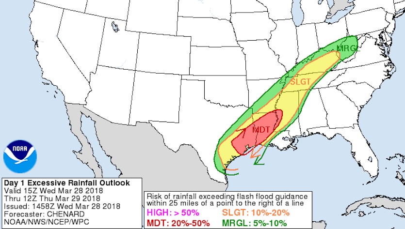
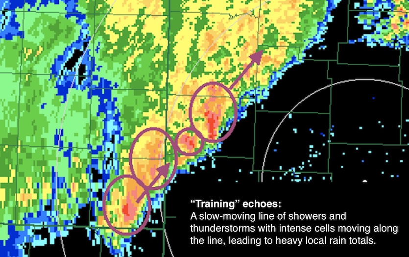
The biggest threat for Wednesday into Thursday is localized flash flooding, especially where “training” bands of showers and thunderstorms may drop several inches of rain across a narrow strip. See the weather.com feature for regular updates.
 |
| Figure 1. Outlook issued at 11 am EDT Wednesday, March 28, for the risk that rainfall will exceed local thresholds for potential flash flooding. Image credit: NOAA/NWS Weather Prediction Center. |
 |
| Figure 2. An example of training echoes: Each of the thunderstorms in this complex (shown here as echoes from Doppler radar) is following the path of the storm ahead of it. The result is a “train” of echoes that sustain rainfall over the same corridor. Flash floods are often associated with training echoes. Image credit: Adapted from Oklahoma Climatological Survey. |
As of Wednesday morning, much of the belt from Texas to Kentucky was under a slight risk of getting enough rainfall to exceed local thresholds for potential flash flooding (see Figure 1). A pocket from southeast Texas to the lower Mississippi River, including the Houston area, was under a moderate risk. Note that these flood risk outlooks are distinct from the severe-weather risk outlooks issued by the NOAA/NWS Storm Prediction Center.
Flooding is no doubt the last thing Houstonians want to deal with, just a few months after the region’s catastrophic encounter with Hurricane Harvey. Rainfall amounts won’t be anywhere close to the 30-plus inches observed with Harvey—the heaviest rains ever to strike a major U.S. city—but totals of 4-5” in spots could be enough to produce flash flooding.
3.05 inches of rain fell overnight/this morning here at the forecast office in New Braunfels. The morning shift had to ford the lake out front to get into the building. pic.twitter.com/5OnxnmY8pP
— NWS Austin/San Antonio (@NWSSanAntonio) March 28, 2018
One sign of the moisture-rich atmosphere flowing into the frontal zone: The 1.80” of precipitable water measured above Corpus Christi, TX, at 12Z Wednesday was the second-highest on record for any date in March across 65 years of radiosonde data. Another clue: the low temperature at Bush Intercontinental Airport on Tuesday was 73°F, which ties the warmest daily low ever recorded in Houston in March (a record set on March 19, 2012). Records in the Houston area go back to 1881.
Setting the (flood) stage
February’s rains helped lay the groundwork for the current flood threat by loading up the soil with moisture and filling many rivers and streams. The Mississippi’s Bonne Carré spillway near New Orleans was opened earlier this month for only the 12th time in its 87-year lifespan (see our related post). Moderate to major river flooding was affecting parts of eastern Louisiana on Wednesday. The Mississippi River at Baton Rouge crested at 43.48 feet last week, the ninth highest crest on record there and the highest water since May 2011.
Prior to the heavy rain in late February, it was dry and the flow on area rivers was low. Fast forward to now, and things have changed. Ground moisture has increased, and minor flooding is ongoing on several rivers. Bottom line: Flooding is more likely than a month ago.#arwx pic.twitter.com/cPvjwWroll
— NWS Little Rock (@NWSLittleRock) March 22, 2018
 |
| Figure 3. Total amount of rainfall for the 30-day period ending at 8 am EDT Wednesday, March 28. Totals of 10-20” were widespread from northeast Texas to southwest Pennsylvania. Image credit: NOAA/NWS Advanced Hydrologic Prediction Service. |
Severe weather may accompany the heavy rains
A slight risk for severe weather was in place along the frontal zone from south Texas to western Mississippi for Wednesday, with the zone shifting toward Alabama on Thursday. No widespread outbreak is expected, but a few tornadoes are possible, most likely short-lived twisters embedded in cells within rainbands.
The lack of major severe weather might seem odd, given the ample low-level moisture on hand and the strong upper low moving across the Plains. However, low-level winds are weak, and the extensive spread of clouds and thunderstorms will tend to reduce instability and work against the formation of more isolated supercells.
Rain at last in one Panhandle—but not in another
It’s not often that a quarter-inch of rain is a huge day-brightener, but the showers that fell across much of the Texas Panhandle surely did the trick on Tuesday. The panhandle is in the grip of an exceptionally nasty drought going back to last autumn. Amarillo picked up 0.24” on Tuesday, its first rainfall of note in close to half a year. Across the 163-day period ending on Monday, Amarillo had seen a mere 0.01” of precipitation. Capital Weather Gang has more on the Panhandle drought and Tuesday’s long-awaited taste of real rain.
The Oklahoma Panhandle missed out on most of Tuesday’s rain, with Guymon notching just 0.01”. Since October 10, Guymon’s total precipitation has been a paltry 0.06”. For the Oklahoma Panhandle as a whole, the last 90 days have been the driest on record for the period Dec. 28-Mar. 27, according to the Oklahoma Climatological Survey. The area received just 0.21” of moisture in those 90 days, compared to the old record of 0.29” (1971-72) and an average of 2.60”.
Severe drought conditions extend well into Kansas and Colorado. Close to half of the winter wheat in Kansas—the nation’s largest producer of the crop—was ranked in poor or very poor condition by the U.S. Department of Agriculture as of Sunday. “The wheat hasn’t gone downhill, it’s never been uphill,” farmer Jay Warner told the McPherson Sentinel.
It is a start, but we'll take it! Some 24 hour rainfall totals across the region. Almost a quarter of an inch officially for Amarillo! #phwx #TXwx #OKwx pic.twitter.com/GsdSsKztIv
— NWS Amarillo (@NWSAmarillo) March 28, 2018


